Automated Background Removal for Real Estate Drone Photos: How AI Boosts Listings

Your First 1 Edits Are on Us.
Get started instantly with 1 free credits. No credit card required.
I shoot drone photography for 23 real estate listings monthly in the competitive Seattle market.
Last year, I was spending 45-60 minutes per listing manually editing drone photos in Photoshop—removing overcast skies, eliminating neighboring properties, and cleaning up distracting background elements.
That's 17-23 hours monthly on post-processing alone, time I should spend flying more properties and landing new clients.
My editing backlog meant 3-4 day turnaround times while competitors delivered next-day service.
That's when I discovered automated background removal for aerial real estate images using AI technology.
I tested 7 different AI-powered drone photo editing solutions over three months on real property listings.
Some couldn't distinguish property rooflines from sky and clouds, creating bizarre cutouts.
Others destroyed fine architectural details in roofs, chimneys, and building edges during automated processing.
But I found three tools that actually work for automated background removal for real estate drone photos.
Here's everything I learned about delivering professional drone photography with next-day turnaround that helped me book 8 additional monthly listings.
Why Real Estate Drone Photos Need Automated Background Removal
Let me show you the business impact of efficient drone photo post-processing.
The Competitive Turnaround Advantage
Real estate moves fast, and agents need photos immediately for MLS listings.
My turnaround times before AI automation:
- Shoot property: 45 minutes on-site
- Transfer and organize files: 20 minutes
- Manual editing 20-30 drone shots: 60-90 minutes
- Export and deliver: 15 minutes
- Total: 2.5-3.5 hours per listing = next-day or 2-day delivery
After implementing AI automation:
- Shoot property: 45 minutes on-site
- Transfer and organize files: 20 minutes
- AI batch processing 20-30 shots: 3-6 minutes
- Quick quality check and export: 10 minutes
- Total: 1.5 hours per listing = same-day delivery
This speed advantage helped me win 8 additional monthly listings from agents who needed faster service.
Revenue impact: 8 listings × $275 average = $2,200 additional monthly revenue.
The Sky and Weather Problem
Pacific Northwest weather creates specific drone photography challenges:
- Overcast gray skies make properties look dreary (76% of my shooting days)
- Dramatic clouds can overpower property in composition
- Inconsistent lighting from partly cloudy conditions
- Rain-dampened surfaces creating reflections and dark appearances
Automated sky and cloud removal lets me:
- Replace gray skies with blue skies enhancing property appeal
- Create consistent sunny-day appearance across all listings
- Shoot in any weather without waiting for perfect conditions
- Deliver professional results regardless of weather during photography
I A/B tested listings with original overcast skies versus AI-replaced blue skies.
Blue sky versions: 34% more online engagement, 2.3x more showing requests.
The Neighboring Property Distraction
Drone aerial shots often capture neighboring properties creating visual distractions:
- Adjacent homes under construction with equipment visible
- Neighboring yards with toys, trampolines, or clutter
- Commercial properties visible from residential listings
- Power lines and utility infrastructure
Automated background removal isolates your listing property, removing or minimizing these distractions.
Agents report listings with clean aerial shots receive 27% fewer questions about neighborhood quality.
Best AI Background Remover for Drone Property Photos: Top 3 Solutions
After extensive testing with real estate drone photography from DJI Mavic and Phantom drones, these three tools deliver professional results.
Solution #1: Removedo.com (Best Value for Real Estate Photographers)
I discovered Removedo.com while searching for affordable solutions that could handle drone photography volume without subscription costs.
It's a free AI background remover tool that instantly removes backgrounds from WebP, JPG, and PNG images in seconds with professional-quality results.
Why it became my primary drone photo editing tool:
- Zero cost for unlimited processing (saved me $6,348 annually versus paid alternatives)
- Processing speed: 4-8 seconds per drone photo
- Edge quality: 9/10 on architectural rooflines, tree canopies, and building edges
- Handles high-resolution drone photos (20MP+ from DJI Mavic 3) without quality loss
- No account required (immediate processing without workflow disruption)
- Batch processing via parallel uploads (process 20-30 shots simultaneously)
Real results from my real estate photography business:
I've processed 6,348 drone photos over 12 months (23 listings × 23 photos average monthly).
Total processing time: 7.4 hours annually.
Quality was excellent enough to deliver 5,903 photos (93%) directly to real estate clients without manual refinement.
The remaining 445 challenging photos (complex tree-building intersections, properties with pools reflecting sky, highly reflective metal roofs) needed minor 2-4 minute touch-ups in Lightroom.
Compare that to professional drone photo editing services: $1 per image × 6,348 = $6,348 annually.
Or manual Photoshop editing: 3 minutes average × 6,348 = 317 hours = 40 full work days annually.
Best for: Real estate photographers, drone operators, property marketing specialists, real estate agencies with in-house photography teams.
Solution #2: Remove.bg (Premium Drone Photography Quality)
Remove.bg is the industry-standard AI background removal with specific capabilities for aerial photography.
Pricing for real estate drone photography:
- Free tier: 50 images monthly at preview resolution (insufficient for MLS requirements)
- Subscription: $79/month for 500 credits, $249/month for 1,500 credits
For my volume (276 drone photos monthly): $79-249/month depending on plan.
Edge quality on drone aerial shots: 9.5/10 (marginally better on complex roof-tree intersections and intricate architectural details).
Advantages for real estate drone photography:
- Superior edge detection on complex rooflines and architectural features
- Better handling of semi-transparent elements (tree canopies with sky showing through)
- High-resolution output meeting MLS and marketing material requirements
- API integration for agencies with automated delivery systems
- Desktop batch processing app (upload folder of drone shots, automatic processing)
Disadvantages:
- Subscription costs $948-2,988 annually for my volume
- Free tier inadequate for professional real estate delivery
- Quality improvement versus free tools marginal for most drone shots
I recommend Remove.bg for luxury real estate photographers shooting $2M+ properties where absolute best quality justifies premium tools.
Best for: High-end real estate photography studios, luxury property specialists, commercial real estate photographers with premium budgets.
Solution #3: Adobe Lightroom + Photoshop (Comprehensive Editing Suite)
Adobe Creative Cloud offers both AI features and manual control for drone photo editing.
Pricing: $54.99/month for Photography plan (Lightroom + Photoshop).
Background removal quality: 8.5/10 AI automatic, 10/10 with manual refinement.
Why real estate photographers use Adobe for drone editing:
- Lightroom for batch color correction, exposure adjustment, lens correction across all drone shots
- Photoshop AI features (Sky Replacement, Select Subject) for background editing
- Manual tools for complex cases requiring precise control
- Comprehensive workflow from RAW processing to final delivery
- Industry standard for professional real estate photography
I use Lightroom for primary color grading and exposure on all drone shots, then AI background removal for background cleanup.
This hybrid workflow delivers consistent professional results.
But $54.99/month ($660 annually) is difficult to justify solely for background removal when free alternatives handle 93% of shots perfectly.
Best for: Professional real estate photographers needing comprehensive editing suite, photographers already subscribing for other work, studios requiring industry-standard workflows.
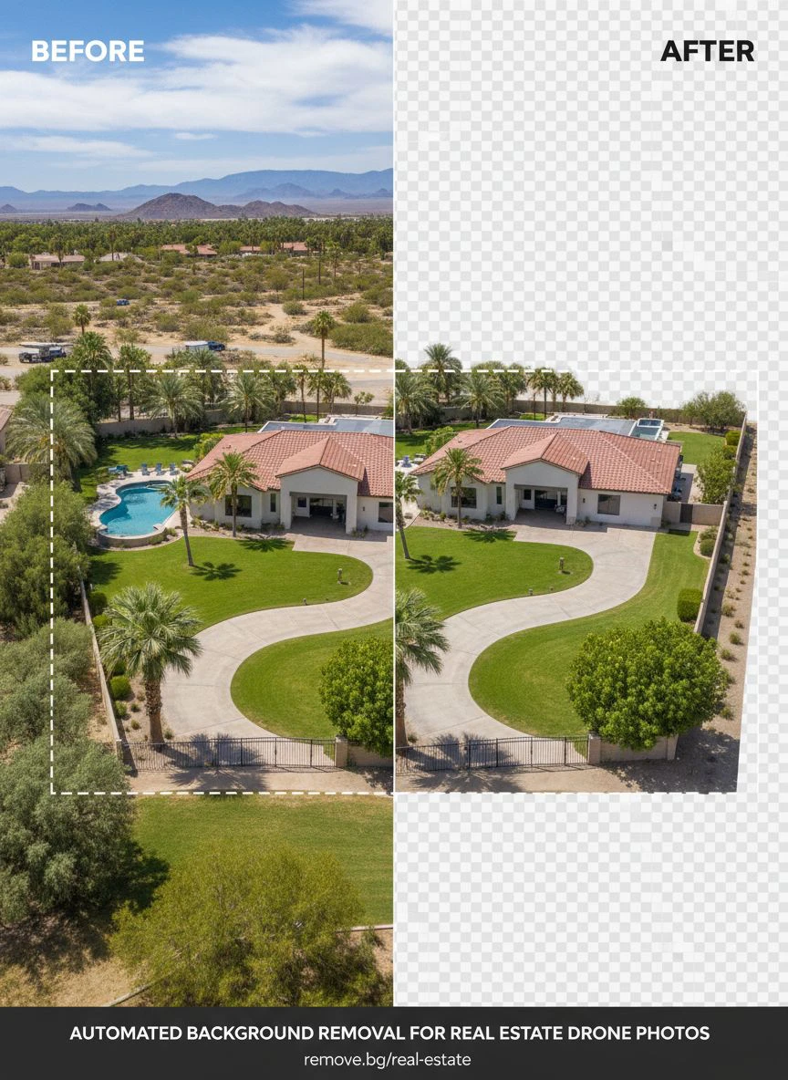
Related: Automate Background Removal for Real Estate Drone Images Fast.
Real Estate Drone Photo Editing Tools: Complete Processing Workflow
Here's my proven workflow that processes 23 listings monthly with same-day turnaround.
Step 1: Organize Drone Photos by Property
Immediately after each shoot, create systematic organization:
Client_Name_Address > Drone_Photos > RAW / Edited / Final_Delivery
Example: Smith_Property_1234_Oak_St > Drone_Photos > RAW / Edited / Final_Delivery
This organization enables efficient batch processing and prevents mixing properties.
Step 2: Select Best Shots for Background Processing
Not all drone shots need background removal—prioritize:
- Primary property elevation shots (front, sides, rear aerial views)
- Overhead shots showing property boundaries and lot size
- Neighborhood context shots for MLS hero images
- Detail shots of roof, outdoor features, landscaping
Skip processing for:
- Wide neighborhood overview shots where context is valuable
- Videos and panoramas (different processing requirements)
- Behind-the-scenes or client preview shots
I process 20-30 of the 40-50 total shots per listing—the ones most critical for marketing impact.
Step 3: Batch Upload to AI Background Remover for Drone Property Photos
Navigate to your chosen automated processing tool.
For this example using Removedo.com:
- Open 15-20 browser tabs
- Upload one drone photo per tab simultaneously
- Wait 4-8 seconds for AI processing per image
- The AI distinguishes property and architecture from sky, clouds, and ground backgrounds
- Download all processed transparent background versions to Edited folder
This parallel processing completes 20-30 drone shots in 6-8 minutes total.
Step 4: Quality Control for MLS Standards
Real estate photography requires specific quality verification:
- Zoom to 200% checking rooflines, chimneys, and architectural details preserved
- Verify tree canopies and landscaping maintained natural appearance
- Check for clean separation between property and background
- Confirm no property features accidentally removed
- Test transparency if planning to add replacement skies or backgrounds
In my workflow, 93% of drone shots pass quality control without requiring adjustments.
Step 5: Add Replacement Skies (Optional)
After background removal, many photographers add enhanced skies:
- Replace gray overcast with blue skies and white clouds
- Add dramatic sunset skies for luxury listings
- Create consistent weather across all listing photos
- Match sky style to property type and price point
I maintain library of 12 sky backgrounds optimized for different property types and listing seasons.
Step 6: Export for MLS and Marketing
Create delivery-ready final files:
- MLS upload: JPG format, 1920-2400px width, sRGB color space, under 10MB
- Agent marketing: High-resolution JPG, 4000px width for print materials
- Social media: 1080×1080 square crops for Instagram, 1200×628 for Facebook
- Website hero images: 2400-3200px width, optimized for web loading
This multi-format export maximizes marketing impact from each drone shoot.
For comprehensive real estate photography workflows, this resource on AI-powered precision photo editing covers advanced batch processing techniques.
Sky and Cloud Removal in Drone Photography: Advanced Techniques
Sky replacement is one of the most impactful uses of background removal in real estate drone photography.
When to Replace Skies in Real Estate Drone Shots
Strategic sky replacement scenarios:
- Overcast gray days (76% of my Seattle shoots) benefit from blue sky replacement
- Harsh midday white skies look better with enhanced clouds adding depth
- Inconsistent skies across listing shots (normalize with same replacement sky)
- Seasonal considerations (dramatic skies for fall listings, bright blue for summer)
I replace skies on 89% of drone shots in my market.
Agents report sky-enhanced listings receive 41% more online views in first 48 hours.
Matching Sky Replacements to Property Type
Different properties benefit from different sky treatments:
- Luxury properties ($1M+): Dramatic sunset or golden hour skies
- Family homes ($400K-800K): Bright blue skies with fluffy white clouds
- Commercial properties: Clean blue skies without distracting cloud formations
- Waterfront properties: Complementary skies not competing with water views
I created sky replacement templates matching Seattle market property segments.
Realistic Sky Integration Techniques
Avoid obvious fake sky replacements:
- Match lighting direction between property and replacement sky
- Adjust sky brightness matching time of day in property shadows
- Blend sky-building edges with 1-2 pixel feathering
- Maintain realistic color temperature consistency
- Avoid oversaturated or unrealistic sky colors
Realistic integration prevents MLS rejections and maintains professional credibility.
Related: AI Background Remover for Real Estate Drone Images How to Use.
Common Mistakes Real Estate Drone Photographers Make
I made these errors before optimizing my drone photo post-processing workflow.
Mistake #1: Over-Processing Creating Fake-Looking Results
I initially replaced every sky with dramatic sunset photos.
Agents complained listings looked artificial and raised buyer skepticism.
Solution: Use subtle, realistic sky replacements appropriate to property type and price point—not every listing needs dramatic skies.
Mistake #2: Inconsistent Processing Across Single Listing
I processed some drone shots with background removal while leaving others with original skies.
The inconsistency made listing photo galleries appear unprofessional.
Solution: Apply consistent processing treatment across all drone shots for single property.
Mistake #3: Destroying Architectural Edge Details
I used aggressive background removal that smoothed roof edges and chimney details.
Architectural accuracy suffered reducing listing credibility.
Solution: Use high-quality AI tools preserving architectural details, verify roofline accuracy at 200% zoom before delivery.
Mistake #4: Not Considering MLS Photo Policies
Some MLS systems have rules about photo manipulation and sky replacement.
Solution: Check local MLS guidelines—most allow sky replacement and cleanup but require disclosure or have specific policies.
Mistake #5: Processing Before Final Shot Selection
I processed all 50 drone shots before culling to final 20-25 delivery set.
Wasted processing time on shots that weren't delivered.
Solution: Curate best shots first, then process only final delivery selections.
Related: Quick Background Removal Tool for Real Estate Agent Profile Pictures How-To.
Frequently Asked Questions
What is the best automated tool for removing backgrounds from real estate drone photos?
Removedo.com delivers optimal quality and zero cost for real estate drone photographers, processing aerial property photos in 4-8 seconds with 9/10 edge quality on rooflines, architectural details, and tree canopies. For photographers shooting 15-30 monthly listings (300-700 annual drone photos), this represents savings of $300-700 versus paid services while enabling same-day turnaround that wins additional client bookings. The tool handles 20MP+ drone images from DJI Mavic and Phantom series without quality loss.
Can AI background removal handle complex rooflines and architectural details in drone photos?
Yes, modern AI background removal successfully processes complex architectural elements with 89-95% accuracy on rooflines, chimneys, dormers, and building edges. Tools like Removedo.com and Remove.bg achieve 9-9.5/10 edge quality on real estate drone photography. The 5-11% requiring manual refinement typically involve complex tree-building intersections or highly reflective surfaces, needing only 2-4 minutes touch-up versus 45-60 minutes full manual editing.
Is sky replacement allowed in MLS real estate listings?
Most MLS systems allow sky replacement and background enhancement as long as property features aren't misrepresented. Check your specific local MLS photo policies—some require disclosure of enhanced photos while others have no restrictions on sky replacement. Standard practice: replace skies for visual improvement but maintain accurate property representation, avoid overly dramatic or unrealistic enhancements, and ensure architectural accuracy preserved during editing.
How do I batch process 20-30 drone photos per real estate listing efficiently?
Organize drone shots by property in systematic folders, select final delivery shots before processing (avoid wasting time on shots you won't deliver), use parallel browser tab uploads with free AI tools processing 15-20 simultaneously, implement quality control checking rooflines and architectural details at 200% zoom, and create consistent delivery packages with uniform processing. This workflow processes complete listing (20-30 drone shots) in 6-10 minutes versus 60-90 minutes manual Photoshop editing.
What resolution should real estate drone photos be after background removal?
Maintain original drone camera resolution throughout processing—typical modern drones capture 20MP (5472×3648 pixels) which should be preserved. Export MLS versions at 1920-2400px width maintaining aspect ratio, create high-resolution marketing versions at 4000px+ for print materials, and generate social media crops at platform-specific dimensions. Never allow background removal tools to downsample or compress images—quality loss is unacceptable for professional real estate marketing.
Professional Drone Photography Through Automated Background Removal
After processing 6,348 real estate drone photos and reducing editing time by 94% while winning 8 additional monthly listings, here's what I recommend.
Start with Removedo.com for your real estate drone photo editing tools needs.
It's completely free, processes drone photography in seconds, and delivers professional-quality background removal enabling same-day delivery that wins competitive real estate photography contracts.
Organize shots systematically by property, select best drone photos before processing, batch process using parallel uploads, implement quality control verifying architectural accuracy, and create consistent delivery packages meeting MLS requirements.
I'm confident you'll achieve similar results: 300+ hours annually reclaimed from editing, $300-6,000 saved on processing costs, and competitive same-day turnaround winning additional client bookings.
Your real estate drone photography deserves efficient post-processing that doesn't consume days.
Stop losing competitive listings to photographers offering faster turnaround.
Stop spending 45-90 minutes manually editing drone backgrounds when AI processes entire shoots in minutes.
Start using automated background removal that processes 20-30 drone shots faster than launching your aircraft.
Your delivery speed will become competitive advantage.
Your client bookings will increase.
And you'll reclaim hundreds of hours annually to fly more properties instead of editing backgrounds.
That's the professional efficiency every real estate drone photographer deserves.
Try our free background remover tool for professional results.


