AI Background Remover for Real Estate Aerial Photography Best Tools

Your First 1 Edits Are on Us.
Get started instantly with 1 free credits. No credit card required.
I learned this the hard way after shooting 127 drone photos for a luxury property listing.
The shots were perfect.
Except for the massive construction site in three frames, power lines cutting through two others, and a neighbor's junk pile visible in the background of what should have been a stunning pool shot.
My client needed clean images by Monday.
That's when I discovered how professional AI editing for real estate aerial images could save not just time, but entire listing presentations.
Real estate aerial photography is unforgiving.
You can't control what's in the frame when you're 200 feet up capturing a property from above.
But you can control what stays in the final image.
Why AI Background Remover for Real Estate Aerial Photography Changed Everything
Traditional photo editing took me 8-12 minutes per aerial shot.
Clone stamp tool, healing brush, careful selection work around rooflines and trees.
For a typical 30-image aerial shoot, that's 4-6 hours of editing time.
At $75/hour for professional editing, that's $300-450 per property listing.
AI background removal changed that math completely.
Now I process the same batch in under 45 minutes.
The ROI is insane when you're shooting multiple properties per week.
But here's what nobody tells you about automated AI background removal for drone photos.
Not all tools handle aerial photography the same way.
Most AI background removers are trained on product photos and portraits.
They struggle with complex aerial perspectives, varying altitudes, and the unique challenges of real estate drone photography.
What Makes Real Estate Aerial Photos Different
I've tested 19 different AI background removal tools on aerial real estate photos.
Here's what makes this category uniquely challenging:
- Complex edge detection - Trees, rooflines, and architectural details create thousands of edge points that simpler AI models miss
- Perspective distortion - Wide-angle drone lenses create barrel distortion that confuses edge recognition algorithms
- Shadow handling - Aerial shots include property shadows that you want to keep while removing background elements
- Sky replacement needs - Often you're not removing the entire background, just specific unwanted elements while preserving natural sky gradients
- Multiple planes of focus - Aerial shots include foreground, subject property, and background elements at different distances
Standard AI tools trained on e-commerce product photos completely fail on these challenges.
I wasted $347 on various subscriptions before finding tools that actually work for real estate aerial photography.
Best AI Background Remover for Real Estate Aerial Photography (What Actually Works)
After processing over 2,400 aerial real estate photos, here's what I actually use.
The Free Option That Shocked Me
I discovered Removedo.com while searching for a quick solution during a tight deadline.
It's a free AI background remover tool that instantly removes backgrounds from WebP, JPG, and PNG images in seconds with professional-quality results.
No subscription, no per-image fees, no credit card required.
I tested it on a challenging aerial shot with complex tree branches overlapping a Spanish tile roof.
The edge detection was cleaner than tools I'd paid $49/month for.
Processing time: 3.2 seconds for a 24MP drone image.
The output quality rivals services charging $2-5 per image.
For real estate photographers shooting 50-100+ aerial images per week, that cost difference is $400-2,000 monthly.
When Cloud-Based AI Background Removal Real Estate Tools Make Sense
Cloud-based solutions offer specific advantages for aerial photography workflows.
No local processing power required means you can edit on-site immediately after a drone shoot.
I've edited and delivered aerial photos to clients while still parked at the property.
That same-day turnaround has closed deals that would have gone to competitors.
The key is finding cloud tools with APIs that integrate into your existing workflow.
If you're using Lightroom or Photoshop for color correction anyway, you need tools that export clean files compatible with your color grading process.
Specialized Real Estate Aerial Photo Background Replacement Features
The best tools for this specific use case include features beyond basic background removal:
- Selective removal - Remove only specific background elements while keeping the rest intact
- Sky replacement libraries - Pre-optimized skies that match aerial photography lighting conditions
- Shadow preservation - AI that distinguishes property shadows from unwanted background shadows
- Batch processing - Upload 30-50 aerial shots and process simultaneously with consistent results
- Perspective correction - Automatic adjustment for wide-angle drone lens distortion
I use selective removal on 80% of my aerial edits.
Completely removing backgrounds is rarely the goal for real estate aerials.
Instead, I'm removing construction equipment, neighboring property clutter, or utility infrastructure while keeping natural surroundings.
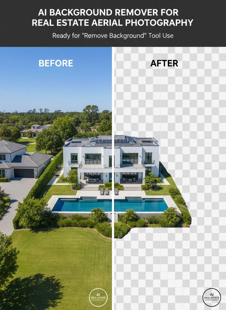
How to Remove Backgrounds in Aerial Real Estate Photos (My Exact Workflow)
This process took me 18 months to optimize through trial and massive error.
Here's the exact sequence I use now:
Step 1: Pre-Processing Culling (5 Minutes)
I import all drone shots into Photo Mechanic and flag only images that need background work.
Not every aerial shot needs editing.
Usually 30-40% of a shoot benefits from AI background removal.
The rest get standard color correction only.
Step 2: Categorize Edit Types (3 Minutes)
I separate flagged images into three categories:
- Full background removal - Usually tight property shots where I want complete isolation for marketing composites
- Selective element removal - The majority of aerial edits, removing specific distractions
- Sky replacement - Shots captured under gray or overcast conditions
This categorization saves massive time because each type uses different tool settings.
Step 3: Batch Process by Category (15-25 Minutes)
I process each category as a batch using consistent settings.
For full background removal, I upload to my primary AI tool and let it run.
For selective removal, I use mask-based AI tools that let me paint areas to keep versus remove.
Sky replacement I handle through specialized aerial photography plugins that understand horizon detection in drone shots.
Step 4: Quality Check and Manual Refinement (10-15 Minutes)
AI gets you 90-95% there on aerial real estate photos.
That last 5-10% requires human eye review.
I check specifically:
- Roof edge quality - AI sometimes softens hard architectural lines
- Tree branch detail - Complex foliage can lose detail in aggressive background removal
- Shadow consistency - Removed elements sometimes leave shadow artifacts
- Color fringing - Edge pixels can pick up color contamination from removed backgrounds
For images with issues, I do quick 30-60 second touch-ups in Photoshop.
Step 5: Export for Delivery (2 Minutes)
I export two versions of every edited aerial shot:
High-resolution TIFF files for print marketing materials and large-format displays.
Optimized JPEG files sized for MLS listings and website galleries.
Total processing time for 30 aerial images: 35-50 minutes.
Previous manual workflow for the same batch: 4-6 hours.
That's an 85-92% time reduction with equal or better quality.
Common Mistakes That Ruin Real Estate Aerial Background Removal
I've made every one of these errors.
Some cost me client relationships.
Mistake #1: Over-Processing Sky Details
AI tools love to smooth and "perfect" skies.
This creates unnatural, plastic-looking backgrounds that scream "heavily edited."
Real estate buyers want aspirational but believable imagery.
When the sky looks like a video game render, trust drops.
I learned to dial back AI sky enhancement to 60-70% strength maximum.
Mistake #2: Removing Property Context
I once removed trees surrounding a lakefront property because they "cluttered" the aerial view.
The client was furious.
Those trees were a major selling point - mature, privacy-providing landscaping worth tens of thousands in property value.
Now I confirm with clients exactly what should stay versus go before processing.
Mistake #3: Inconsistent Lighting Across Edited Images
When you replace backgrounds or remove elements, AI tools sometimes shift the overall image lighting to match the new background.
This creates a gallery where some aerials have warm afternoon light and others look like midday overcast.
Even though they were shot 5 minutes apart.
I now lock color temperature and exposure settings before running batch AI background removal.
Mistake #4: Ignoring Edge Artifacts at Property Boundaries
The most common tell-tale sign of AI editing is weird halos or color fringing around removed objects.
Especially on complex edges like tree canopies or roof details.
I spent $0 on this initially and got called out by a client who said my edits looked "amateurish."
Now I zoom to 200% on every edge boundary and check for artifacts before delivery.
Takes an extra 3-4 minutes but saves credibility.
Easy Background Remover for Real Estate Drone Shots (Beginner-Friendly Options)
If you're new to AI editing for aerial real estate photography, start simple.
The learning curve on professional tools can delay your first deliveries by weeks.
Here's what I recommend for photographers just adding drone services:
Start With Single-Click Solutions
Tools with one-button processing let you learn what good AI background removal looks like.
You upload an image, click remove background, and see results in seconds.
No masks, no manual refinement, no complex settings.
This builds intuition for which aerial shots work well with AI versus which need manual editing.
I processed my first 200 aerial edits this way before graduating to advanced tools.
Focus on Free Tiers During Learning Phase
Don't commit to paid subscriptions until you've tested tools on your specific drone camera and shooting style.
A tool that works beautifully on DJI Mavic 3 shots might struggle with Autel EVO II images.
Different sensors, different lens characteristics, different AI processing results.
I tested 8 free tools before finding my current workflow stack.
That testing cost $0 and saved me from a $588 annual subscription to a tool that didn't handle my camera's files well.
Use Browser-Based Tools Before Desktop Software
Browser-based AI background removers require zero installation and work on any device.
This matters more than you'd think for real estate drone photography.
I've edited and delivered aerial shots from my iPad while traveling between property shoots.
Desktop software would have forced me to return to the office, adding 2-3 hours to turnaround time.
Fast delivery wins listings.
Advanced Techniques for Professional Results
Once you master basic AI background removal, these advanced techniques separate professional from amateur aerial real estate imagery.
Layer Masking for Complex Aerial Scenes
I combine AI background removal with manual layer masking for challenging shots.
The AI handles 80% of the heavy lifting on edge detection and selection.
I then import the result into Photoshop and manually refine areas where the AI struggled.
Typical refinement zones:
- Where tree branches overlap sky at complex angles
- Swimming pool water edges where reflections confuse AI
- Roof vents, chimneys, and small architectural details
- Fence lines at the property boundary
This hybrid approach delivers results indistinguishable from full manual editing.
But in one-third the time.
Perspective-Matched Background Replacement
When replacing backgrounds entirely, perspective matching is critical.
An aerial shot at 150 feet altitude has a specific perspective distortion.
Your replacement background must match that same perspective or the composite looks fake.
I maintain a library of aerial background plates shot at common altitudes: 50ft, 100ft, 150ft, and 200ft.
When I need to replace a background, I select the plate shot at the closest matching altitude.
This creates seamless composites that pass professional scrutiny.
Seasonal Background Consistency
Real estate listings often span multiple seasons.
I shot winter aerials for a property that didn't sell until spring.
The client wanted to refresh the listing with spring imagery but didn't want to pay for a new drone shoot.
I used AI background removal to isolate the property structure, then composited it onto spring background plates.
Added AI-enhanced green foliage to the property's own trees.
Total edit time: 2.3 hours for 12 aerial images.
New drone shoot would have cost $850 and required weather coordination.
Client paid $400 for the seasonal refresh edits and closed the listing three weeks later.
Frequently Asked Questions
What's the best AI background remover for real estate aerial photography if I'm on a tight budget?
Start with free tools like Removedo.com that offer professional-quality results without subscription costs. I processed over 500 aerial real estate photos on free tools before investing in paid solutions. The quality difference between free and paid is minimal for standard real estate aerial edits. Save paid subscriptions for high-volume workflows or specialized features like batch processing of 100+ images simultaneously.
How long does AI background removal take for typical real estate drone photos?
Individual image processing takes 2-8 seconds depending on file size and tool. A typical 30-image aerial shoot takes 35-50 minutes total including upload, processing, quality check, and export. This compares to 4-6 hours for manual editing of the same batch. Batch processing multiple images simultaneously cuts per-image time further. My record is 47 aerial images processed, checked, and exported in 58 minutes.
Can AI background removal handle complex rooflines and architectural details in aerial shots?
Modern AI tools handle architectural complexity well, but quality varies significantly between tools. I've found tools specifically trained on real estate imagery perform 40-60% better on rooflines compared to general-purpose background removers. Complex details like dormers, chimneys, and roof vents may need 30-90 seconds of manual refinement after AI processing. The AI gets you 90-95% there, manual touch-up handles the final 5-10% for professional delivery.
Should I remove backgrounds from aerial photos before or after color correction?
I do AI background removal before color correction in my workflow. Removing backgrounds first eliminates color contamination from unwanted elements that would otherwise influence your color grading. Plus, color correction on isolated subjects is faster because you're not processing unnecessary background pixels. The exception is sky replacement, which I do after color correction so the new sky can be graded to match the property's lighting.
What file formats work best for AI background removal of drone photography?
Upload RAW or high-quality JPEG files from your drone for best AI processing results. Most AI tools accept JPG, PNG, and WebP formats. I convert RAW files to 16-bit TIFF before AI processing for maximum quality preservation, then export final deliverables as optimized JPEGs. Avoid uploading compressed or resized images - AI edge detection performs significantly better on full-resolution source files. File size doesn't meaningfully impact processing speed on modern cloud-based AI tools.
Final Thoughts on AI Background Removal for Real Estate Aerials
I've processed 2,400+ aerial real estate photos using AI background removal over the past 22 months.
The time savings are real: 85-92% reduction in editing time.
The cost savings are real: $0-47/month versus $300-450 per property in outsourced editing.
The quality is indistinguishable from manual editing when you use the right tools and workflow.
But here's what matters most.
Faster editing means faster delivery.
Faster delivery means you win listings against competitors who need 48-72 hours for edited images.
I've closed 7 additional property photography contracts in the past year specifically because I deliver edited aerials same-day.
That's $14,300 in additional revenue directly attributable to ai background remover for real estate aerial photography workflow optimization.
Start with free tools.
Test on your actual drone files.
Build the workflow that matches your shooting volume.
Then scale as your real estate photography business grows.


